
The drive to Zion was about a 5-hour drive from the Grand Canyon. Along the way, I looked at campsites in Zion and found that the campgrounds were full (two campgrounds are reservable in advance, and the third at Lava Point is first come first serve campground, but only has 6 sites and is about an hour from the valley). Fortunately, we had family friends in St. George, Utah, who were generous enough to host us for a few days, so we headed to their house instead. This also meant a nice, hot shower after our backpacking trip!
We were still sore from our few days at the Grand Canyon, so we wanted to take it easy the next day. Snow Canyon State Park was nearby and offers several hiking trails. Our friends had recommended a few, so we did a combination of the Lava Flow, Butterfly, and Petrified Dunes trails, creating a loop starting/ending at the Butterfly trailhead. The hike was about 4 miles total with not much elevation gain (only for the overlook point). There are a few lava tubes along the Lava Flow trail, which are cave-like features that you can hike down into (only partially for some). We spent some time exploring a couple of these – it does get very dark quickly, so bring a headlamp! Then we continued to the overlook, which was definitely worth the short climb – you can see the beautiful scenery within the park. We got a little lost on the Butterfly trail and ended up walking through thick sand for a while (there was a compacted gravel path that we somehow missed a turn off for). Then we climbed up the petrified dunes, also very neat features! The hike took us about 2 hours, including our lava tube exploration time. After the hike, we headed back to the house for a good, long day of football.


Zion is only about an hour from St. George, so we planned to do day trips there for the next few days. We had been warned that Zion gets very busy, so we needed to get there early in the morning if we wanted to try to do the Angel’s Landing hike. With this in mind, we left the house the next morning around 6:15 am and arrived at Zion around 7:15 am. During the fall season, the first shuttle starts at 7 am, and by the time we parked, it looked like we would be catching the 3rd or 4th shuttle. So, we scratched Angel’s Landing for the day and instead checked in the visitor’s center for hiking alternatives for the day. The visitor center and backcountry office were not helpful. Their recommendations were limited to pointing me towards some binders with the trail information so that we could research what we wanted to do. Fortunately, I had some cell service here, so we looked at the internet’s recommendations instead. We ended up heading to the northwest part of the park (where you don’t have to take a shuttle to get to the trailheads). The Hop Valley trailhead was approximately 45 minutes from the visitor center. When we arrived, there was one other car parked at the trailhead. The hike to Hop Valley is 3 miles one way. It’s a nice walk, slightly down as you head into the valley. We walked about 2.5 miles before the trail became much steeper on the final approach into the valley. At this point, we could see down into the valley (beautiful views), and didn’t feel like making the climb back up, so we turned around here. The 5-mile round trip hike took us 2.5 hours. Then we headed back to St. George for the afternoon.


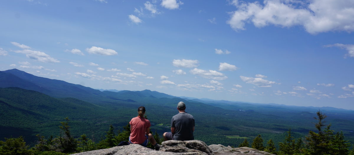
We learned from our mistakes the previous day and arrived before 7 am the next morning to attempt Angel’s Landing. We still didn’t make the first shuttle, but we were on the second. The shuttle system at Zion is nice – they play informative recordings and all the drivers have great, interesting park facts, almost like tour guides for the parks. Honestly, the drivers were more helpful than the visitor’s center! For the Angel’s Landing hike, you take the shuttle to stop #6 (the Grotto). You cross the street and take the trail to the right. It’s about 2 miles up to Scout’s Lookout and another 0.7 miles out on the chains to Angel’s Landing (1,600 feet elevation gain total). Fortunately, we hiked the first 2 miles quickly (took us about 40 minutes), so we were able to pass a number of people from the first shuttle. It wasn’t too crowded when we started the chains; there were still a decent number of people, but the dreaded lines/traffic from 2-way travel hadn’t started yet. We climbed our way to the top in about 20 minutes. The hike is not as bad as people describe it. There were no portions where you didn’t have something to hold on to or lean up against. That being said, still not a great hike for those afraid of heights. At the top, you can walk out on the ledge for the best views into Zion valley. We would have stayed longer at the top, but the longer you stay, the more traffic there will be on the way back down. It took us about 30 minutes to get back to Scout’s Lookout. We are glad we did it, but the crowds really detract from the enjoyment of the hike. I’m not sure I would ever do it again. Once we arrived back at Scout’s Lookout, we continued north to the West Rim trail based on a recommendation from a friend. We didn’t know what we were getting into at the time. It is a climb up to the West Rim trail – 3 miles from Scout’s Lookout with about 2,000 feet of elevation gain. The views once you get up onto the trail are incredible! Plus, the fall colors were arriving, which enhanced the scenery. Once we got to the top, we continued another 1-1.5 miles before turning around and heading all the way back down to the Grotto trailhead. In total, we hiked about 13.4 miles with 3,600 feet of elevation gain, which took about 6.5 hours total. An exhausting, but great day! If I were to do the West Rim trail again, I would hire a car/shuttle to take us up to Lava Point and walk the entire 15.8 miles. From this direction, it’s all downhill! It is also a popular backpacking trip, which we had thought about doing, but backpacking in Zion requires carrying out all waste (i.e., digging a hole is not acceptable) which wasn’t for us.


Our last day (and night in St. George) in Zion was spent doing the famous Narrows! We had rented water shoes, socks, hiking sticks, and a waterproof bag from Zion Outfitters the previous day, which is absolutely worth it! The shoes provide nice support, so you feel more confident walking along the rocky riverbed. Note that you do not need a permit for this hike if you only hike the downstream portion. We got to the park a little later in the morning because we didn’t want to do this hike in the early morning cold (you can rent pants from Zion Outfitters as well, but we elected not to). By the time we got to the park (around 10 am), the parking lot was full, so we were forced to pay for parking ($20) in the town of Springdale. We were able to park the car close enough to walk into the park, without having to take the separate Springdale shuttle. We then took the Zion shuttle to the last stop, the Temple of Sinawava (stop #9). There is a short (~1 mile) riverwalk that leads to the start of the Narrows hike. This portion of the hike is very crowded. While it does thin out once you start the Narrows portion, it is still crowded throughout the entire hike. Only about 60-70% of the hike is within the river itself; the remaining 30-40% is up on rocks or sand banks (although you can walk in the river for the entire hike). Going out is a bit tougher than coming back as you are hiking against the current. A few sections of the hike are waist deep, but for the most part, the river was only up to our knees (at least when we hiked in October). We hiked out a little less than 2 hours before reaching the junction to Orderville Canyon and Wall Street. Wall Street is the area of the Narrows that is typically photographed and publicized, so we wanted to explore this area. We continued about 45 minutes past the junction before turning around. It only took about 1.5 hours to get back to the bus stop, so our total hike time was about 4 hours. Overall the hike was a fun experience, but chilly in October. We didn’t wait long for a shuttle back to the visitor’s center. On the shuttle ride, we were able to catch a glimpse of the baby California Candor stretching its wings at bus stop #8 (Big Bend) up in the net. Apparently, its learning to fly, and its wingspan is huge! From the visitor’s center, we walked back to our car and returned our water gear. Then, we headed to Bryce Canyon!


When we got to Bryce Canyon about two hours later after 5 pm, the campground was full (only one of two campgrounds was open). So, we ended up at the Bryce Canyon Pines campground, which is located behind the Chevron gas station about 10 miles from the park. Really nothing special, but a place to stay. The temperatures that night dropped to 15 degrees that night, and I don’t think we could do anything much colder. The next morning, we waited until the sun heated up our tent a little before getting up (around 9 am). The next night was supposed to get down to 8 degrees, and we knew that we were not equipped for 8-degree camping as we had been cold the previous night. Unfortunately, that meant we could not stay near Bryce Canyon for another night and therefore only had one day to check out Bryce!
It was still cold, so we didn’t feel up to hiking. But Bryce has great, drivable viewpoints. The park road extends south about 20 miles with viewpoints down the entire stretch. Our favorite was Bryce Point – it gave a great view of the famous amphitheater and hoo-doos. The “Natural Bridge” which is actually a natural arch by definition, is also well-worth the stop. We were disappointed that the weather wasn’t better and would like to come back to hike in the future! Driving the park road and stopping at all the viewpoints only took about two hours. We then left Bryce Canyon and headed for Capitol Reef National Park as it was supposed to be a little warmer there for the night (20 degree or so).


Upon arriving at Capitol Reef National Park, we learned that the one campground in the park, Fruita, is reservable and was full for the night. The rangers at the visitor’s center were friendly and the park had a nice map that highlighted hikes and things to do. It’s a rather large park and difficult to navigate as there is one main road that cuts east/west and then a short scenic drive running south. The two first come first serve primitive campgrounds in the park have 5 and 6 sites and are 30 miles and 45 miles from the visitor’s center. We thought about trying one of these for the night, and if full, we could disperse camp in adjacent BLM land. However, we would have to go down dirt roads to get to the primitive campgrounds, which we are always hesitant to do with no cell service. We also weren’t loving the landscape of this park, and with no great camping option, we decided to skip this park and continue to the Arches/Canyonlands/Moab area. On the way, we saw some irrigation lines that must have frozen during the night and were still running the next morning – very strange!


Beautiful Pictures What a beautiful country we have